The University of Toronto Mississauga Library has a small collection of aerial photographs for research and study purposes. These are located in the Map Collection area on Level One of the Library near the Smart Classrooms.
The map below is an index to our holdings. Our collection covers portions of Southern Ontario with photos being taken by the Ontario Department of Lands and Forests through the mid-1950s.
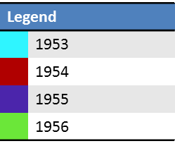
The Index displays aerial photos separated by colour to indicate the year the photo collection was taken.

UTM Library Aerial Photo holdings
- Zoom in on your area of interest using the zoom tools in the map or by using the mouse wheel
- Pan within the map by clicking and dragging
- Clicking on the icon will provide a pop-up window, with photo number information
- With the photo number, you will be able to obtain the photo from our collection